Moyerson taxadjunct-Firehole-Corlett taxadjunct complex, 1 to 15 percent slopes
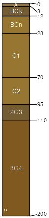
Moyerson taxadjunct
(35%)
Saline Upland Green River and Great Divide Basins (SU)
Sodic Ustic Haplocambids
Well drained
Hydric: No
PAWS: 6 cm
basin-floor remnants
Firehole
(25%)
Loamy Green River and Great Divide Basins (Ly)
Sodic Ustic Haplocambids
Well drained
Hydric: No
PAWS: 22 cm
hillslopes / Backslope
Corlett taxadjunct
(20%)
Sandy Green River and Great Divide Basins (Sy)
Ustic Torripsamments
Somewhat excessively drained
Hydric: No
PAWS: 22 cm
dunes
Scooby taxadjunct
(10%)
Clayey Green River and Great Divide Basins (Cy)
Sodic Ustic Haplocambids
Well drained
Hydric: No
PAWS: 34 cm
hillslopes / Backslope
Craighigh taxadjunct
(5%)
Very Shallow Green River and Great Divide Basins (VS)
Ustic Torriorthents
Well drained
Hydric: No
PAWS: 3 cm
hillslopes / Backslope
Elkol taxadjunct
(5%)
Saline Upland Green River and Great Divide Basins (SU)
Ustertic Torriorthents
Well drained
Hydric: No
PAWS: 14 cm
hillslopes / Shoulder
SSA
Scale
Published
Export
wy737
1:24,000
2025-09-04