Shermap-Groveland complex, 10 to 35 percent slopes
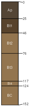
Shermap
(60%)
Steep Loamy (SLy) Absaroka Upper Foothills
Pachic Argiustolls
Well drained
Hydric: No
PAWS: 31 cm
complex landslides
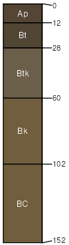
Groveland
(20%)
Lowland (LL) Absaroka Upper Foothills
Oxyaquic Argiustolls
Somewhat poorly drained
Hydric: No
PAWS: 35 cm
complex landslides
Alamosa-like
(10%)
Subirrigated (Sb) Absaroka Upper Foothills
Typic Argiaquolls
Poorly drained
Hydric: No
PAWS: 37 cm
sags
Sawbuck
(10%)
Skeletal (Sk) Absaroka Upper Foothills
Typic Argiustolls
Well drained
Hydric: No
PAWS: 18 cm
complex landslides
SSA
Scale
Published
Export
wy629
1:24,000
2025-09-04