Bonjea-Chugcreek-like-Shermap complex, 35 to 60 percent slopes
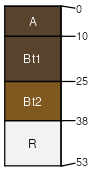
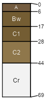
Bonjea
(35%)
Shallow Igneous (SwIg) Absaroka Upper Foothills
Lithic Argiustolls
Well drained
Hydric: No
PAWS: 5 cm
mountain slopes
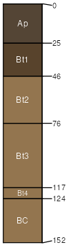
Chugcreek-like
(25%)
Shallow Igneous (SwIg) Absaroka Lower Foothills
Pachic Argiustolls
Well drained
Hydric: No
PAWS: 13 cm
mountain slopes
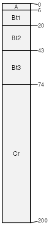
Shermap
(20%)
Steep Loamy (SLy) Absaroka Upper Foothills
Pachic Argiustolls
Well drained
Hydric: No
PAWS: 34 cm
mountain slopes
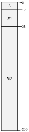
Shermap-like
(10%)
Overflow (Ov) Absaroka Upper Foothills
Pachic Argiustolls
Well drained
Hydric: No
PAWS: 34 cm
mountain slopes
Rangecreek
(5%)
Igneous (Ig) Absaroka Lower Foothills
Aridic Ustorthents
Well drained
Hydric: No
PAWS: 1 cm
mountain slopes
Rock outcrop
(5%)
Hydric: No
PAWS: NA
SSA
Scale
Published
Export
wy629
1:24,000
2025-09-04