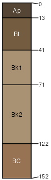
Varney-Anamac complex, 2 to 8 percent slopes
Varney
(50%)
Sandy (Sy) 10-14 PZ Frigid
Calcidic Argiustolls
Well drained
Hydric: No
PAWS: 17 cm
hills / Footslope
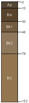
Anamac
(40%)
Overflow (Ov) 10-14 PZ Frigid
Aridic Haplustolls
Well drained
Hydric: No
PAWS: 18 cm
hills / Footslope
swales
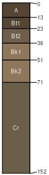
Udecide
(8%)
Sandy (Sy) 10-14 PZ Frigid
Aridic Argiustolls
Well drained
Hydric: No
PAWS: 15 cm
hills / Shoulder
hills / Backslope
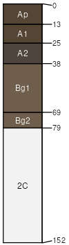
Meadowcreek
(2%)
Subirrigated Shrubland
Fluvaquentic Haplustolls
Somewhat poorly drained
Hydric: Yes
PAWS: 17 cm
drainageways
SSA
Scale
Published
Export
mt670
1:24,000
2007
2025-09-03