Haugan-Walstead-Farnuf complex, 8 to 25 percent slopes
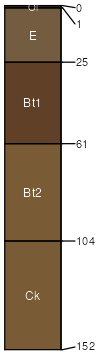
Haugan
(40%)
Steep Loamy (SLy) Absaroka Upper Foothills
Typic Haplustalfs
Well drained
Hydric: No
PAWS: 24 cm
complex landslides
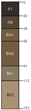
Walstead
(30%)
Cobbly Upland (CoU) Absaroka Upper Foothills
Typic Haplustolls
Well drained
Hydric: No
PAWS: 15 cm
complex landslides
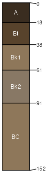
Farnuf
(20%)
Overflow (Ov) Absaroka Upper Foothills
Typic Argiustolls
Well drained
Hydric: No
PAWS: 33 cm
complex landslides
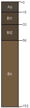
Pachel
(10%)
Overflow (Ov) Absaroka Upper Foothills
Pachic Argiustolls
Well drained
Hydric: No
PAWS: 17 cm
complex landslides
SSA
Scale
Published
Export
wy629
1:24,000
2025-09-04