Sawbuck-Arnegard association, 10 to 30 percent slopes
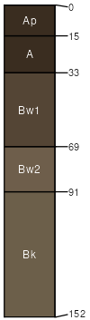
Sawbuck
(50%)
Cobbly Upland (CoU) Absaroka Upper Foothills
Typic Argiustolls
Well drained
Hydric: No
PAWS: 19 cm
complex landslides
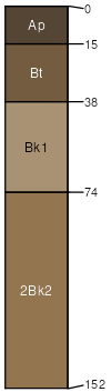
Arnegard
(40%)
Overflow (Ov) Absaroka Upper Foothills
Pachic Haplustolls
Well drained
Hydric: No
PAWS: 35 cm
complex landslides
Meagher
(10%)
Stony Upland (StU) Absaroka Upper Foothills
Typic Argiustolls
Well drained
Hydric: No
PAWS: 17 cm
complex landslides
SSA
Scale
Published
Export
wy629
1:24,000
2025-09-04