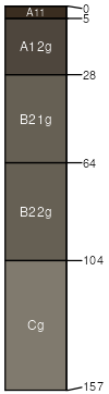
Fulmer-Levelton complex, 0 to 5 percent slopes
Fulmer
(55%)
Subirrigated High Plains Southeast (Sb)
Typic Endoaquolls
Very poorly drained
Hydric: Yes
PAWS: 26 cm
flood plains
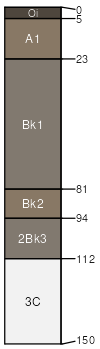
Levelton
(30%)
Wetland (Foothills And Mountains Southeast)
Vertic Endoaquepts
Very poorly drained
Hydric: Yes
PAWS: 33 cm
flood plains
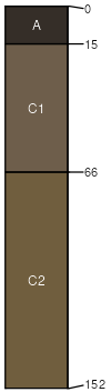
Gash
(10%)
Oxyaquic Ustifluvents
Moderately well drained
Hydric: No
PAWS: NA
flood plains / Toeslope
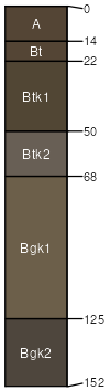
Hereimcreek
(5%)
Subirrigated High Plains Southeast (Sb)
Aquic Argiustolls
Somewhat poorly drained
Hydric: No
PAWS: 36 cm
flood-plain steps / Toeslope
SSA
Scale
Published
Export
wy630
1:24,000
2025-09-04