Bonhigh-Qcreek-Rock outcrop complex, 10 to 45 percent slopes
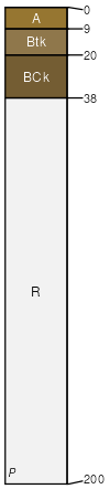
Bonhigh
(35%)
Loamy High Plains Southeast (Ly)
Aridic Haplustalfs
Well drained
Hydric: No
PAWS: 8 cm
dip slopes / Backslope
Qcreek
(30%)
Shale High Plains Southeast (Sh)
Aridic Ustorthents
Well drained
Hydric: No
PAWS: 5 cm
homoclinal ridges / Backslope
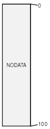
Rock outcrop
(15%)
Hydric: No
PAWS: NA
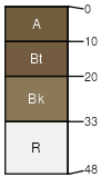
Joegale
(10%)
Shallow Loamy High Plains Southeast (SwLy)
Lithic Haplustalfs
Well drained
Hydric: No
PAWS: 6 cm
hillslopes / Shoulder
Kayso
(5%)
Sandy High Plains Southeast (Sy)
Calcidic Haplustalfs
Well drained
Hydric: No
PAWS: 16 cm
dip slopes / Backslope
Blackleaf
(5%)
Shallow Breaks High Plains Southeast (SwBr)
Lithic Haplustalfs
Somewhat excessively drained
Hydric: No
PAWS: 6 cm
homoclinal ridges / Shoulder
SSA
Scale
Published
Export
wy630
1:24,000
2025-09-04