Harleston-Urban land complex, 0 to 2 percent slopes
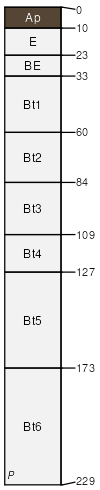
Harleston
(55%)
West Central Loamy Flat
Aquic Paleudults
Moderately well drained
Hydric: No
PAWS: 19 cm
stream terraces / Toeslope
Urban land
(30%)
Hydric:
PAWS: NA
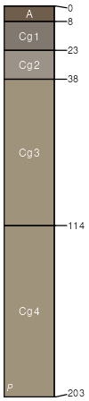
Bibb
(5%)
Typic Fluvaquents
Poorly drained
Hydric: Yes
PAWS: 23 cm
flood plains
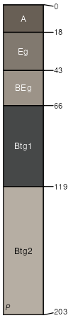
Smithton
(5%)
Typic Paleaquults
Poorly drained
Hydric: Yes
PAWS: 30 cm
flats / Toeslope
drainageways
SSA
Scale
Published
Export
al097
1:24,000
2018
2025-09-10