Oquaga and Lordstown channery silt loams, steep, rubbly
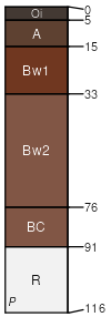
Oquaga
(50%)
Well Drained Till Uplands
Typic Dystrudepts
Well drained
Hydric: No
PAWS: 9 cm
hills / Summit
hills / Shoulder
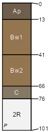
Lordstown
(30%)
Well Drained Till Uplands
Typic Dystrudepts
Well drained
Hydric: No
PAWS: 13 cm
hills / Backslope
Rock outcrop
(7%)
Hydric:
PAWS: NA
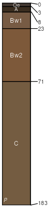
Cadosia
(5%)
Typic Dystrudepts
Well drained
Hydric: No
PAWS: 18 cm
ridges / Backslope
ridges / Footslope
Arnot
(5%)
Shallow Till Uplands
Lithic Dystrudepts
Somewhat excessively drained
Hydric: No
PAWS: 6 cm
hills / Backslope
hills / Shoulder
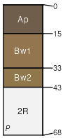
Wellsboro
(3%)
Moist Dense Till
Typic Fragiudepts
Moderately well drained
Hydric: No
PAWS: 10 cm
hills / Summit
hills / Shoulder
SSA
Scale
Published
Export
pa079
1:20,000
1974
2025-09-03