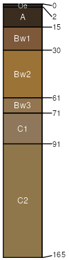
Charlton (50%)
Well Drained Till Uplands
Typic Dystrudepts
Well drained
Hydric: No
PAWS: 24 cm |
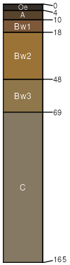
hills / Summit hills / Shoulder hills / Backslope
|
|
Chatfield (30%)
Well Drained Till Uplands
Typic Dystrudepts
Well drained
Hydric: No
PAWS: 11 cm |
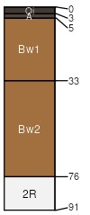
ridges / Summit ridges / Shoulder ridges / Backslope
|
|
Rock outcrop (5%)
Hydric: No
PAWS: NA |

|
|
Hollis (5%)
Lithic Dystrudepts
Somewhat excessively drained
Hydric: No
PAWS: 7 cm |
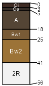
ridges / Summit ridges / Shoulder ridges / Backslope
|
|
Leicester (5%)
Aeric Endoaquepts
Poorly drained
Hydric: Yes
PAWS: 19 cm |
|
|
Sutton (5%)
Aquic Dystrudepts
Moderately well drained
Hydric: No
PAWS: 19 cm |
|
|