Tootall-Rentsac-Chugcreek family complex, 4 to 25 percent slopes
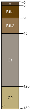
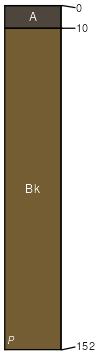
Tootall
(35%)
Shallow Clayey Foothills and Basins West (SwCy)
Torrertic Haplustalfs
Well drained
Hydric: No
PAWS: 26 cm
hillslopes / Backslope
Rentsac
(25%)
Shallow Clayey Foothills and Basins West (SwCy)
Lithic Calciustepts
Well drained
Hydric: No
PAWS: 3 cm
hillslopes / Backslope
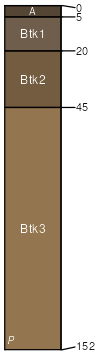
Chugcreek
(15%)
Loamy Foothills and Basins West (Ly)
Pachic Argiustolls
Well drained
Hydric: No
PAWS: 8 cm
hillslopes / Backslope
Mantlemine
(10%)
Shallow Loamy Foothills and Basins West (SwLy)
Calcidic Haplustalfs
Well drained
Hydric: No
PAWS: 25 cm
hillslopes / Backslope
Bronec
(10%)
Gravelly Foothills and Basins West (Gr)
Aridic Calciustepts
Well drained
Hydric: No
PAWS: 8 cm
hillslopes / Shoulder
Joebas
(5%)
Shallow Loamy Foothills and Basins West (SwLy)
Lithic Haplustalfs
Well drained
Hydric: No
PAWS: 7 cm
hillslopes / Backslope
SSA
Scale
Published
Export
wy723
1:24,000
2025-09-04