Polaris-Blackleaf-Tootall family complex, 8 to 35 percent slopes
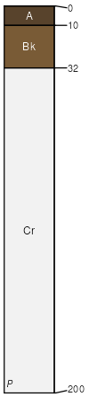
Polaris
(35%)
Shallow Breaks Foothills and Basins West (SwBr)
Aridic Calciustepts
Well drained
Hydric: No
PAWS: 4 cm
hillslopes / Backslope
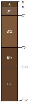
Blackleaf
(30%)
Shallow Breaks Foothills and Basins West (SwBr)
Lithic Haplustalfs
Well drained
Hydric: No
PAWS: 2 cm
hillslopes / Shoulder
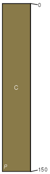
Tootall family
(25%)
Shallow Breaks Foothills and Basins West (SwBr)
Torrertic Haplustalfs
Well drained
Hydric: No
PAWS: 25 cm
hillslopes / Summit
Mussel family
(10%)
Shallow Breaks Foothills and Basins West (SwBr)
Aridic Ustorthents
Well drained
Hydric: No
PAWS: 29 cm
hillslopes / Shoulder
SSA
Scale
Published
Export
wy723
1:24,000
2025-09-04