Arahustan-Ohanapecosh-Longmire complex, 15 to 100 percent slopes
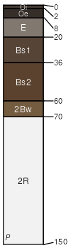
Arahustan
(50%)
Southern Washington Cascades Low Cryic Coniferous Forest
Andic Haplocryods
Well drained
Hydric: No
PAWS: 10 cm
ridges
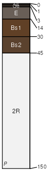
Ohanapecosh
(25%)
Southern Washington Cascades Low Cryic Coniferous Forest
Lithic Haplocryods
Well drained
Hydric: No
PAWS: 6 cm
ridges
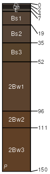
Longmire
(15%)
Southern Washington Cascades Low Cryic Coniferous Forest
Andic Haplocryods
Well drained
Hydric: No
PAWS: 16 cm
ridges
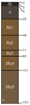
Vantrump
(5%)
Southern Washington Cascades Moist Low Cryic Coniferous Forest
Typic Cryaquands
Somewhat poorly drained
Hydric: No
PAWS: 18 cm
ridges
Rock outcrop
(5%)
Hydric: No
PAWS: NA
ridges
SSA
Scale
Published
Export
wa634
1:24,000
1986
2025-08-28