Thorndike-Elliottsville complex, 15 to 45 percent slopes, very rocky
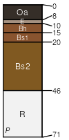
Thorndike
(45%)
Shallow And Moderately Deep Till
Lithic Haplorthods
Somewhat excessively drained
Hydric: No
PAWS: 7 cm
mountains / Summit
mountains / Shoulder
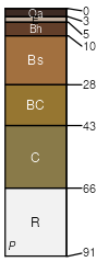
Elliottsville
(40%)
Shallow And Moderately Deep Till
Typic Haplorthods
Well drained
Hydric: No
PAWS: 17 cm
mountains / Backslope
SSA
Scale
Published
Export
me610
1:20,000
1992
2025-08-29