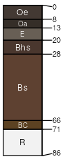
Lyman (38%)
Shallow and Moderately-deep Till
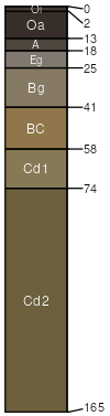
Lithic Haplorthods
Somewhat excessively drained
Hydric: No
PAWS: 9 cm |
mountains hills / Summit hills / Shoulder hills / Backslope
|
|
|
Rock outcrop (18%)
Rockland (reserved)
Hydric: Unranked
PAWS: NA |

mountains hills / Summit hills / Shoulder hills / Backslope
|
|
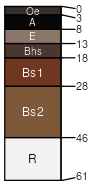
Monadnock (5%)
Typic Haplorthods
Well drained
Hydric: No
PAWS: 15 cm |
mountains hills / Summit hills / Shoulder hills / Backslope
|
|
Marlow (5%)
Typic Haplorthods
Well drained
Hydric: No
PAWS: 18 cm |
mountains hills / Summit hills / Shoulder hills / Backslope
|
|
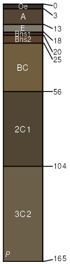
Brayton (4%)
Aeric Endoaquepts
Poorly drained
Hydric: Yes
PAWS: 28 cm |
mountains hills / Summit hills / Shoulder hills / Backslope
|
|
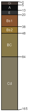
Abram (2%)
Lithic Udorthents
Excessively drained
Hydric: No
PAWS: 3 cm |

mountains hills / Summit hills / Shoulder hills / Backslope
|
|