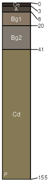
Canton (40%)
Well Drained Till Uplands
Typic Dystrudepts
Well drained
Hydric: No
PAWS: 19 cm |
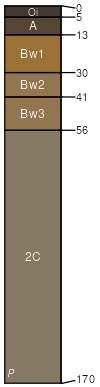
hills / Summit hills / Shoulder hills / Backslope
|
|
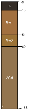
Chatfield (35%)
Well Drained Till Uplands
Typic Dystrudepts
Well drained
Hydric: No
PAWS: 11 cm |
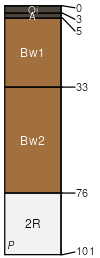
ridges / Summit ridges / Shoulder ridges / Backslope
|
|
Hollis (20%)
Shallow Dry Till Uplands
Lithic Dystrudepts
Somewhat excessively drained
Hydric: No
PAWS: 7 cm |
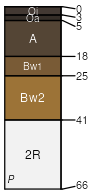
ridges / Summit ridges / Shoulder ridges / Backslope
|
|
Montauk (2%)
Oxyaquic Dystrudepts
Well drained
Hydric: No
PAWS: 23 cm |
hills / Summit hills / Shoulder hills / Backslope
|
|
Ridgebury (1%)
Aeric Endoaquepts
Poorly drained
Hydric: Yes
PAWS: 21 cm |
|
|
Rock outcrop (1%)
Hydric: No
PAWS: 0 cm |

|
|
Scituate (1%)
Oxyaquic Dystrudepts
Moderately well drained
Hydric: No
PAWS: 15 cm |
hills / Summit hills / Backslope hills / Footslope
|
|