Littletahoma-Burroughs-Mountwow, moist complex, 20 to 100 percent slopes
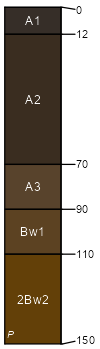
Littletahoma
(40%)
Southern Washington Cascades Moist Subalpine Parkland
Humic Vitricryands
Well drained
Hydric: No
PAWS: 23 cm
glacial-valley walls
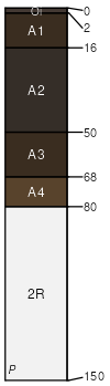
Burroughs
(25%)
Southern Washington Cascades Moist Subalpine Parkland
Humic Vitricryands
Well drained
Hydric: No
PAWS: 14 cm
glacial-valley walls
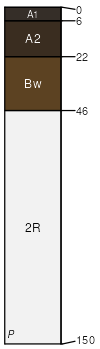
Mountwow
(15%)
Southern Washington Cascades Moist Subalpine Parkland
Thaptic Cryaquands
Somewhat poorly drained
Hydric: No
PAWS: 19 cm
glacial-valley walls
Tatoosh
(10%)
Southern Washington Cascades Moist Subalpine Parkland
Lithic Vitricryands
Well drained
Hydric: No
PAWS: 7 cm
glacial-valley walls
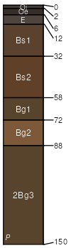
Unicornpeak
(5%)
Southern Washington Cascades High Cryic Coniferous Forest
Aquandic Haplocryods
Moderately well drained
Hydric: No
PAWS: 25 cm
glacial-valley walls
Rock outcrop
(5%)
Hydric: No
PAWS: NA
glacial-valley walls
SSA
Scale
Published
Export
wa754
1:24,000
2015
2025-08-28