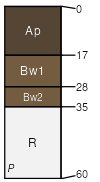
Kings Falls (70%)
Shallow Rich Till Upland
Lithic Eutrudepts
Well drained
Hydric: No
PAWS: 5 cm |

hills / Summit hills / Shoulder
|
|
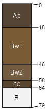
Nehasne (10%)
Well drained
Hydric: No
PAWS: NA |

hills / Summit hills / Shoulder hills / Backslope
|
|
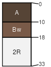
Galoo (9%)
Somewhat excessively drained
Hydric: No
PAWS: NA |

|
|
Lacustrine over till (5%)
Hydric: No
PAWS: NA |

hills / Summit hills / Shoulder
|
|
Nehasne (5%)
Moderately well drained
Hydric: No
PAWS: NA |

hills / Summit hills / Shoulder hills / Backslope
|
|
Rock outcrop (1%)
Hydric: Unranked
PAWS: NA |

hillsides or mountainsides / Shoulder hillsides or mountainsides / Backslope
|
|