Rothican-Colhill complex, 2 to 10 percent slopes
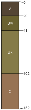
Rothican
(50%)
Loamy-West (16-20 PZ)
Aridic Calciustolls
Well drained
Hydric: No
PAWS: 19 cm
valleys / Backslope
valleys / Footslope
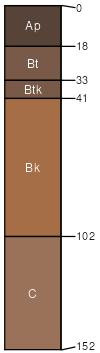
Colhill
(30%)
Very Shallow (VS) 15-19 Precipitation Zone, Black Hills
Typic Ustorthents
Excessively drained
Hydric: No
PAWS: 13 cm
knolls / Summit
knolls / Backslope
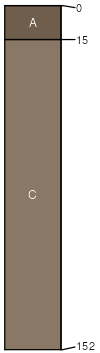
Sugakool
(10%)
Loamy-West (16-20 PZ)
Typic Argiustolls
Well drained
Hydric: No
PAWS: 18 cm
fan remnants / Footslope
Rock outcrop
(10%)
Non-site
Excessively drained
Hydric: No
PAWS: 6 cm
SSA
Scale
Published
Export
wy045
1:24,000
1984
2025-09-04