Wynott-Wilkes-Enon complex, 2 to 15 percent slopes, moderately eroded
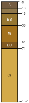
Wynott
(41%)
Basic Upland Forest, Depth Restriction, Dry
Typic Hapludalfs
Well drained
Hydric: No
PAWS: 10 cm
hills / Summit
hills / Shoulder
hills / Backslope
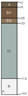
Wilkes
(39%)
Basic Upland Forest, Depth Restriction, Dry
Typic Hapludalfs
Well drained
Hydric: No
PAWS: 6 cm
hills / Summit
hills / Shoulder
hills / Backslope
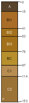
Enon
(20%)
Basic upland forest, moist
Ultic Hapludalfs
Well drained
Hydric: No
PAWS: 20 cm
hills / Summit
hills / Shoulder
hills / Backslope
SSA
Scale
Published
Export
ga639
1:24,000
2012
2025-08-29