Comodore-Toothaker complex, 5 to 50 percent slopes
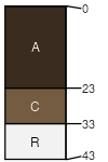
Comodore
(50%)
Shallow Loamy (Foothills And Mountains Southeast)
Aridic Lithic Haplustolls
Well drained
Hydric: No
PAWS: 3 cm
ridges / Summit
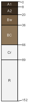
Toothaker
(35%)
Shallow Loamy (Foothills And Mountains Southeast)
Aridic Haplustalfs
Well drained
Hydric: No
PAWS: 12 cm
hillslopes / Shoulder
hillslopes / Backslope
Beeftrail
(13%)
Igneous Foothills and Mountains West
Aridic Haplustolls
Well drained
Hydric: No
PAWS: 5 cm
hillslopes / Backslope
Rock outcrop
(2%)
Well drained
Hydric: Unranked
PAWS: NA
SSA
Scale
Published
Export
wy630
1:24,000
2025-09-04