Rockerville (50%)
Shallow Loamy - South
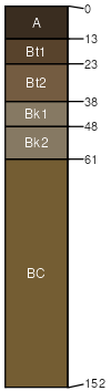
Lithic Calciustolls
Somewhat excessively drained
Hydric: No
PAWS: 3 cm |
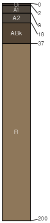
ridges / Summit ridges / Shoulder
|
|
Gurney (35%)
Loamy - South
Typic Argiustolls
Well drained
Hydric: No
PAWS: 13 cm |
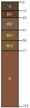
mountain slopes / Backslope mountain slopes / Footslope
|
|
Ziggy (4%)
Thin Upland
Typic Haplustepts
Well drained
Hydric: No
PAWS: 30 cm |
hillslopes / Backslope hillslopes / Footslope
|
|
Sawdust (4%)
Thin Upland
Typic Ustorthents
Well drained
Hydric: No
PAWS: 14 cm |
ridges / Summit ridges / Shoulder ridges / Backslope
|
|
Hilger (4%)
Stony Hills
Typic Argiustolls
Well drained
Hydric: No
PAWS: 17 cm |
mountain slopes / Shoulder mountain slopes / Backslope
|
|
Rock outcrop (3%)
Non-site
Excessively drained
Hydric: No
PAWS: 2 cm |

ledges / Shoulder ledges / Backslope
|
|