Huguston-Haterton complex, 3 to 6 percent slopes -- draft
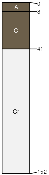
Huguston
(50%)
Very Shallow Green River and Great Divide Basins (VS)
Ustic Torriorthents
Well drained
Hydric: No
PAWS: 3 cm
hills / Backslope
ridges / Shoulder
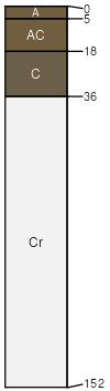
Haterton
(40%)
Shale Green River and Great Divide Basins (Sh)
Ustic Torriorthents
Well drained
Hydric: No
PAWS: 4 cm
hills / Backslope
ridges / Backslope
SSA
Scale
Published
Export
wy737
1:24,000
2025-09-04