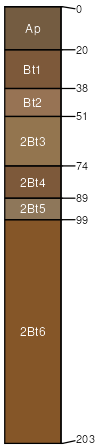
Lostpond silt loam, 1 to 3 percent slopes, rarely flooded
Lostpond
(85%)
Wet Upland Drainageway Forest
Aquic Hapludalfs
Somewhat poorly drained
Hydric: No
PAWS: 29 cm
drainageways
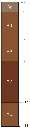
Moniteau
(5%)
Wet Upland Drainageway Forest
Typic Paleaquults
Poorly drained
Hydric: Yes
PAWS: 40 cm
stream terraces
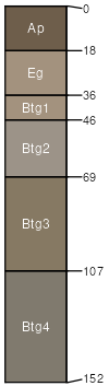
Britwater
(5%)
Loamy Terrace Forest
Typic Paleudalfs
Well drained
Hydric: No
PAWS: 23 cm
paleoterraces
Higdon
(5%)
Wet Footslope Forest
Aquic Hapludalfs
Somewhat poorly drained
Hydric: No
PAWS: 39 cm
divides / Footslope
SSA
Scale
Published
Export
mo149
1:24,000
2004
2025-09-02