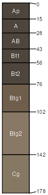
Tanglenook silt loam, 1 to 3 percent slopes, rarely flooded
Tanglenook
(90%)
Wet Upland Drainageway Forest
Typic Argiaquolls
Poorly drained
Hydric: Yes
PAWS: 34 cm
drainageways
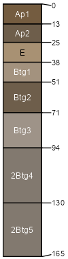
Deible
(5%)
Wet Upland Drainageway Forest
Typic Albaqualfs
Poorly drained
Hydric: Yes
PAWS: 32 cm
stream terraces
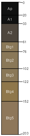
Farewell
(5%)
Wet Upland Drainageway Forest
Typic Argiaquolls
Somewhat poorly drained
Hydric: Yes
PAWS: 28 cm
flood plains
SSA
Scale
Published
Export
mo105
1:24,000
1997
2025-09-02