Lowassie silt loam, 0 to 3 percent slopes, frequently ponded
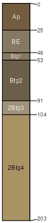
Lowassie
(90%)
Ponded Sinkhole Wetland
Vertic Epiaquults
Poorly drained
Hydric: Yes
PAWS: 38 cm
sinkholes / Toeslope
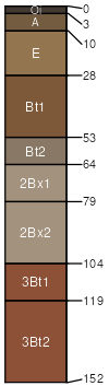
Celt
(5%)
Fragipan Upland Flatwoods
Aquic Fragiudults
Somewhat poorly drained
Hydric: No
PAWS: 20 cm
interfluves / Summit
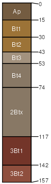
Plato
(3%)
Fragipan Upland Flatwoods
Aquic Fragiudalfs
Somewhat poorly drained
Hydric: No
PAWS: 15 cm
interfluves / Summit
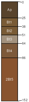
Splitlimb
(2%)
Ponded Sinkhole Wetland
Aquic Paleudults
Somewhat poorly drained
Hydric: No
PAWS: 38 cm
interfluves / Summit
SSA
Scale
Published
Export
mo109
1:24,000
1979
2025-09-02