Eram silt loam, 2 to 5 percent slopes, eroded
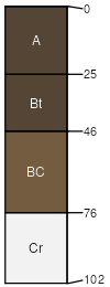
Eram
(95%)
Clayey Upland
Aquic Argiudolls
Moderately well drained
Hydric: No
PAWS: 9 cm
interfluves / Summit
interfluves / Shoulder
Coweta
(3%)
Shallow Sandstone Upland
Typic Hapludolls
Well drained
Hydric: No
PAWS: 5 cm
hillslopes / Backslope
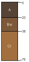
Deepwater
(2%)
Loamy Upland
Typic Argiudolls
Moderately well drained
Hydric: No
PAWS: 36 cm
interfluves / Summit
interfluves / Shoulder
SSA
Scale
Published
Export
mo217
1:24,000
1974
2025-09-02