Wellsville-Medbow complex, 2 to 15 percent slopes
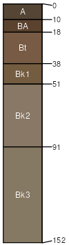
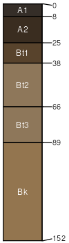
Wellsville
(45%)
Loamy (Foothills And Mountains Southeast)
Ustic Argicryolls
Well drained
Hydric: No
PAWS: 22 cm
cuestas / Summit
Medbow
(30%)
Gravelly High Plains Southeast (Gr)
Ustic Haplocryalfs
Well drained
Hydric: No
PAWS: 14 cm
cuestas / Shoulder
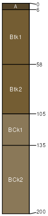
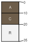
Sledrunner
(9%)
Clayey (Cy) 15-19 Foothills and Mountains East Precipitation Zone
Vertic Haplocryalfs
Well drained
Hydric: No
PAWS: 27 cm
cuestas / Backslope
Calpet
(7%)
Loamy (Foothills And Mountains Southeast)
Ustic Haplocryalfs
Well drained
Hydric: No
PAWS: 13 cm
cuestas / Summit
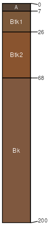
Ratiopeak
(5%)
Coarse Upland (CU) 15-19 Foothills and Mountains East Precipitation Zone
Ustic Argicryolls
Well drained
Hydric: No
PAWS: 19 cm
cuestas / Shoulder
cuestas / Summit
Starman
(4%)
Shallow Loamy (Foothills And Mountains Southeast)
Lithic Cryorthents
Well drained
Hydric: No
PAWS: 3 cm
hillslopes / Shoulder
hillslopes / Summit
SSA
Scale
Published
Export
wy630
1:24,000
2025-09-04