Fort Mott-Cedartown complex, 15 to 25 percent slopes
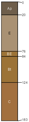
Fort Mott
(50%)
Well Drained Coarse-Loamy Upland
Arenic Hapludults
Well drained
Hydric: No
PAWS: 18 cm
flats
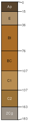
Cedartown
(45%)
Sandy, Excessively Drained Upland
Psammentic Hapludults
Somewhat excessively drained
Hydric: No
PAWS: 17 cm
flats
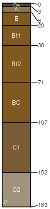
Woodstown
(5%)
Moist Loamy Upland
Aquic Hapludults
Moderately well drained
Hydric: No
PAWS: 27 cm
broad interstream divides
swales
depressions
SSA
Scale
Published
Export
md009
1:20,000
1967
2025-09-09