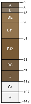
Westmoreland silt loam, 15 to 35 percent slopes
Westmoreland
(80%)
Divergent Uplands
Ultic Hapludalfs
Well drained
Hydric: No
PAWS: 16 cm
mountain slopes / Backslope
mountain slopes / Shoulder
mountain slopes / Summit
SSA
Scale
Published
Export
wv713
1:24,000
2025-09-08