Subwater-Merna-Jonsouth complex, 1 to 6 percent slopes
Subwater
(45%)
Sands Green River and Great Divide Basins (Sa)
Ustic Natrargids
Well drained
Hydric: No
PAWS: 23 cm
interdunes
Merna
(30%)
Sands Green River and Great Divide Basins (Sa)
Ustic Natrargids
Well drained
Hydric: No
PAWS: 16 cm
dunes
Jonsouth
(15%)
Saline Upland Green River and Great Divide Basins (SU)
Ustic Natrargids
Well drained
Hydric: No
PAWS: 11 cm
interdunes
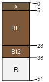
Chalkhill
(10%)
Shallow Sandy Green River and Great Divide Basins (SwSy)
Lithic Ustic Haplargids
Well drained
Hydric: No
PAWS: 4 cm
hillslopes / Summit
hillslopes / Shoulder
SSA
Scale
Published
Export
wy635
1:24,000
2025-09-04