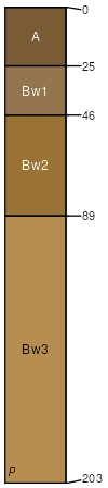
Urban Land-Cecil complex, 2 to 10 percent slopes, moderately eroded
Urban land
(52%)
Hydric: Unranked
PAWS: NA
hillslopes / Summit
hillslopes / Shoulder
hillslopes / Backslope
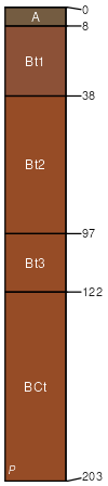
Cecil
(42%)
Acidic upland forest, moist
Typic Kanhapludults
Well drained
Hydric: No
PAWS: 25 cm
interfluves / Backslope
interfluves / Shoulder
interfluves / Summit
Chewacla
(6%)
Fluvaquentic Dystrudepts
Somewhat poorly drained
Hydric: No
PAWS: 38 cm
flood plains / Toeslope
SSA
Scale
Published
Export
sc091
1:16,000
2013
2025-08-29