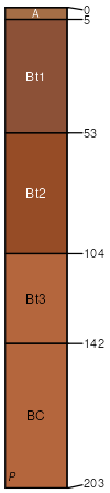
Georgeville silty clay loam, 2-6 percent slopes, moderately eroded
Georgeville
(97%)
Acidic upland forest, moist
Typic Kanhapludults
Well drained
Hydric: No
PAWS: 27 cm
interfluves / Backslope
interfluves / Shoulder
interfluves / Summit
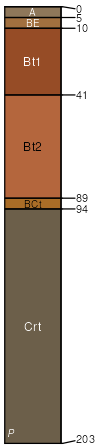
Badin
(3%)
Typic Hapludults
Well drained
Hydric: No
PAWS: 11 cm
interfluves / Backslope
SSA
Scale
Published
Export
sc091
1:16,000
2013
2025-08-29