Rockerville (31%)
Shallow Loamy - North
Lithic Calciustolls
Well drained
Hydric: No
PAWS: 5 cm |
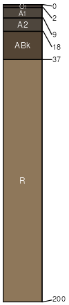
dip slopes / Summit dip slopes / Backslope
|
|
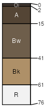
Pesowyo (29%)
Thin Upland
Typic Haplustolls
Well drained
Hydric: No
PAWS: 7 cm |
|
|
Rockerville (25%)
Very Shallow
Lithic Ustorthents
Excessively drained
Hydric: No
PAWS: 2 cm |
dip slopes / Summit dip slopes / Backslope
|
|
Rock outcrop (10%)
Non-site
Excessively drained
Hydric: No
PAWS: 0 cm |

dip slopes / Summit dip slopes / Shoulder dip slopes / Backslope
|
|
Gurney (5%)
Loamy - North
Typic Argiustolls
Well drained
Hydric: No
PAWS: 12 cm |
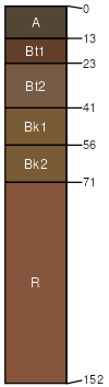
mountain slopes / Backslope mountain slopes / Footslope
|
|