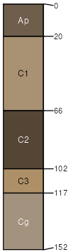
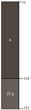
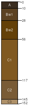
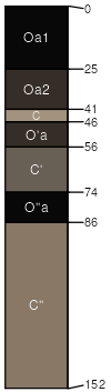
Algansee-Kalmarville complex, river valleys, 0 to 3 percent slopes, frequently flooded

Algansee (55%)
Wet Sandy Floodplain
Aquic Udipsamments
Somewhat poorly drained
Hydric: Yes
PAWS: 15 cm
flood plains / Toeslope
Kalmarville (30%)
Floodplain Swamp Forest
Mollic Fluvaquents
Poorly drained
Hydric: Yes
PAWS: 24 cm
flood plains / Toeslope
overflow stream channels / Toeslope
Scotah (4%)
Wet Sandy Floodplain
Typic Udipsamments
Moderately well drained
Hydric: No
PAWS: 15 cm
flood plains / Summit
Kerston (4%)
Mucky Swamp
Fluvaquentic Haplosaprists
Very poorly drained
Hydric: Yes
PAWS: 75 cm
flood plains / Toeslope
Water (3%)


Hydric:
PAWS: NA
Riverwash (2%)


Hydric:
PAWS: NA
flood plains / Toeslope
Northbend (2%)
Loamy Floodplains
Fluvaquentic Dystrudepts
Somewhat poorly drained
Hydric: Yes
PAWS: 24 cm
flood plains
SSAScalePublishedExport
wi0531:20,00019942023-09-08