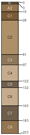
Westerville-Kaintuck complex, 0 to 3 percent slopes, frequently flooded
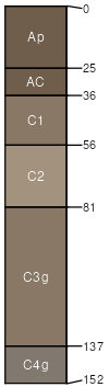
Westerville
(50%)
Wet Floodplain Step Forest
Aeric Fluvaquents
Somewhat poorly drained
Hydric: No
PAWS: 42 cm
flood plains
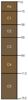
Kaintuck
(35%)
Sandy/Gravelly Floodplain Forest
Typic Udifluvents
Well drained
Hydric: No
PAWS: 24 cm
flood plains
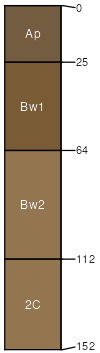
Haymond
(5%)
Loamy Floodplain Forest
Dystric Fluventic Eutrudepts
Well drained
Hydric: No
PAWS: 38 cm
flood plains / Toeslope
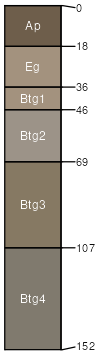
Moniteau
(5%)
Wet Terrace Forest
Typic Endoaqualfs
Poorly drained
Hydric: Yes
PAWS: 43 cm
flood plains / Toeslope
Wideman
(5%)
Gravelly/Loamy Upland Drainageway Forest
Typic Udifluvents
Excessively drained
Hydric: No
PAWS: 21 cm
drainageways / Toeslope
SSA
Scale
Published
Export
mo223
1:24,000
2004
2025-09-02