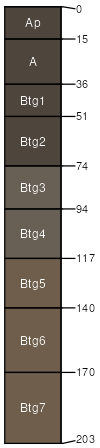
Raftville-Gabriel complex, 1 to 3 percent slopes, rarely flooded
Raftville
(50%)
Gravelly/Loamy Upland Drainageway Forest
Typic Hapludalfs
Well drained
Hydric: No
PAWS: 13 cm
drainageways / Toeslope
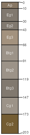
Gabriel
(30%)
Wet Upland Drainageway Forest
Typic Argiaquolls
Poorly drained
Hydric: Yes
PAWS: 39 cm
drainageways / Toeslope
Raftville
(10%)
Gravelly/Loamy Upland Drainageway Forest
Typic Hapludalfs
Well drained
Hydric: No
PAWS: 13 cm
stream terraces / Toeslope
Gabriel
(7%)
Wet Upland Drainageway Forest
Typic Argiaquolls
Poorly drained
Hydric: Yes
PAWS: 39 cm
stream terraces / Toeslope
Baylock
(3%)
Wet Upland Drainageway Forest
Typic Endoaqualfs
Poorly drained
Hydric: Yes
PAWS: 41 cm
flood-plain steps / Toeslope
SSA
Scale
Published
Export
mo203
1:24,000
2004
2025-09-02