Martinsdale-Whitlash, bouldery-Catgulch complex, 4 to 25 percent slopes
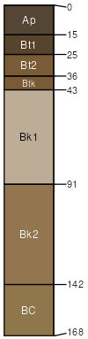
Martinsdale
(35%)
Upland Grassland Group
Typic Argiustolls
Well drained
Hydric: No
PAWS: 26 cm
mountain slopes
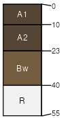
Whitlash
(30%)
Shallow Grassland Group
Lithic Haplustolls
Well drained
Hydric: No
PAWS: 3 cm
mountain slopes
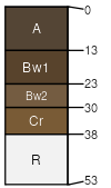
Catgulch
(25%)
Shallow Grassland Group
Lithic Haplustolls
Well drained
Hydric: No
PAWS: 4 cm
mountain slopes
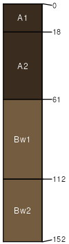
Bowery
(5%)
Silty (Si) RRU 46-C 13-19 PZ
Pachic Haplustolls
Well drained
Hydric: No
PAWS: 26 cm
swales
Rock outcrop
(5%)
Hydric: No
PAWS: NA
SSA
Scale
Published
Export
mt624
1:24,000
2021
2025-08-30