Limberjim-Bullroar-Syrupcreek-Terrodd complex, 0 to 30 percent slopes
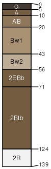
Limberjim
(30%)
Cool Wet Conifer Mountains and Plateaus (ABGR/VAME/LIBO)
Alfic Udivitrands
Well drained
Hydric: No
PAWS: 17 cm
plateaus
mountain slopes / Backslope
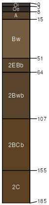
Bullroar
(25%)
Cool Wet Conifer Mountains and Plateaus (ABGR/VAME/LIBO)
Typic Udivitrands
Well drained
Hydric: No
PAWS: 19 cm
mountain slopes / Toeslope
plateaus
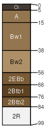
Syrupcreek
(20%)
Cool Wet Conifer Mountains and Plateaus (ABGR/VAME/LIBO)
Alfic Udivitrands
Well drained
Hydric: No
PAWS: 13 cm
plateaus
mountain slopes / Backslope
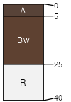
Terrodd
(15%)
Mountain Riparian Forest (PIEN/ALIN)
Cumulic Hapludolls
Moderately well drained
Hydric: No
PAWS: 15 cm
mountain valleys
Melloe
(5%)
Typic Cryaquolls
Poorly drained
Hydric: Yes
PAWS: 15 cm
mountain slopes
Bocker
(5%)
Lithic Haploxerolls
Well drained
Hydric: No
PAWS: 2 cm
plateaus
mountain slopes
SSA
Scale
Published
Export
or631
1:24,000
2018
2025-09-10