Quartzhill-Hardteph association
Quartzhill
(50%)
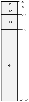
Ashy Shallow Loam 14-16 P.Z.
Vitrandic Argixerolls
Well drained
Hydric: No
PAWS: 7 cm
mountains / Backslope
Hardteph
(35%)
Ashy Claypan 12-14 P.Z.
Lithic Argixerolls
Well drained
Hydric: No
PAWS: 5 cm
mountains / Shoulder
Vitritorrandic Argixerolls
(5%)
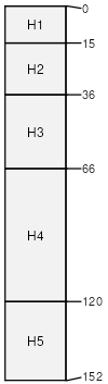
SHALLOW LOAM 12-14 P.Z.
Vitritorrandic Argixerolls
Well drained
Hydric: No
PAWS: 7 cm
mountains / Backslope
Tephzite
(3%)
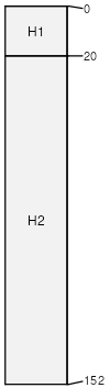
GRAVELLY LOAMY SLOPE 14-16 P.Z.
Vitrandic Argixerolls
Well drained
Hydric: No
PAWS: 25 cm
mountains / Backslope
Vertic Palexerolls
(3%)
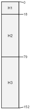
Ashy Claypan 12-14 P.Z.
Vertic Palexerolls
Well drained
Hydric: No
PAWS: 16 cm
mountains / Footslope
Rock outcrop
(2%)
Hydric: No
PAWS: NA
mountains
Vitrandic Haploxerolls
(1%)
Streambank
Vitrandic Haploxerolls
Well drained
Hydric: No
PAWS: 8 cm
stream terraces
Aquandic Cryaquolls
(1%)
Ashy Semi-Wet Meadow
Aquandic Cryaquolls
Poorly drained
Hydric: Yes
PAWS: 22 cm
flood plains
SSA
Scale
Published
Export
ca686
1:24,000
2010
2025-09-08