Bandana-Tate-Nikwasi complex, 0 to 15 percent slopes, frequently flooded
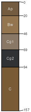
Bandana
(39%)
Non-Hydric Floodplains
Aeric Fluvaquents
Somewhat poorly drained
Hydric: No
PAWS: 14 cm
flood plains
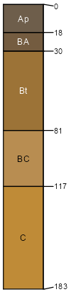
Tate
(19%)
Non-Hydric Floodplains
Typic Hapludults
Well drained
Hydric: No
PAWS: 28 cm
stream terraces
mountain slopes / Footslope
mountain slopes / Toeslope
Nikwasi
(11%)
Non-Hydric Floodplains
Cumulic Humaquepts
Very poorly drained
Hydric: Yes
PAWS: 23 cm
flood plains
SSA
Scale
Published
Export
nc097
1:12,000
2011
2025-09-02