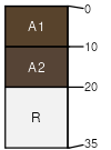
Vershal-Absarokee-Whitlash complex, 4 to 15 percent slopes
Vershal
(50%)
Shallow Grassland Group
Lithic Haplustolls
Well drained
Hydric: No
PAWS: 2 cm
plains
plains
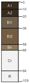
Absarokee
(35%)
Upland Sagebrush Shrubland Group
Typic Argiustolls
Well drained
Hydric: No
PAWS: 12 cm
plains
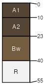
Whitlash
(15%)
Shallow Alpine Group
Lithic Haplustolls
Well drained
Hydric: No
PAWS: 5 cm
plains
plains
SSA
Scale
Published
Export
mt632
1:24,000
2025-08-30