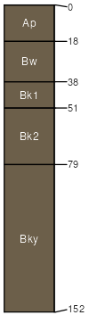
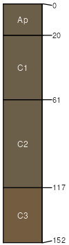
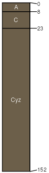
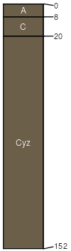
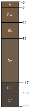
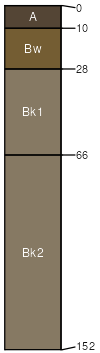
Kobase-Harlake, rarely flooded-Lostriver, rarely flooded complex, 0 to 4 percent slopes

Kobase (45%)
Clayey (Cy) RRU 58A-C 11-14 p.z.
Torrertic Haplustepts
Well drained
Hydric: No
PAWS: 24 cm
stream terraces
Harlake (25%)
Clayey (Cy) RRU 58A-C 11-14 p.z.
Aridic Ustifluvents
Well drained
Hydric: No
PAWS: 24 cm
flood plains
Lostriver (15%)
Saline Upland (SU) RRU 58A-C 11-14 p.z.
Aridic Ustifluvents
Well drained
Hydric: No
PAWS: 20 cm
flood plains
Bullhook (5%)
Silty (Si) RRU 58A-C 11-14 p.z.
Aridic Ustifluvents
Well drained
Hydric: No
PAWS: 21 cm
flood plains
Yamacall (5%)
Silty (Si) RRU 58A-C 11-14 p.z.
Aridic Haplustepts
Well drained
Hydric: No
PAWS: 21 cm
stream terraces
Zatoville (5%)
Clayey (Cy) RRU 58A-C 11-14 p.z.
Torrertic Haplustepts
Well drained
Hydric: No
PAWS: 13 cm
stream terraces
SSAScalePublishedExport
mt6241:24,00020212023-08-25