Cortyzack-Ryedraw complex, 4 to 25 percent slopes, dissected
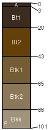
Cortyzack
(40%)
Loamy Foothills and Basins West (Ly)
Calcidic Argiustolls
Well drained
Hydric: No
PAWS: 25 cm
hills / Backslope
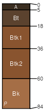
Ryedraw
(35%)
Coarse Upland Foothills and Basins West (CU)
Calcidic Argiustolls
Well drained
Hydric: No
PAWS: 14 cm
hills / Backslope
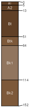
Fergus
(10%)
Vertic Argiustolls
Well drained
Hydric: No
PAWS: NA
hills / Summit
hills / Shoulder
hills / Backslope
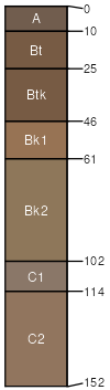
Mantlemine
(5%)
Calcidic Haplustalfs
Well drained
Hydric: No
PAWS: NA
hills / Shoulder
Coarse-loamy Aridic haplustalfs
(5%)
Aridic Haplustalfs
Well drained
Hydric: No
PAWS: NA
hills / Backslope
eroded fan remnant sideslopes / Backslope
Geohrock
(5%)
Aridic Haplustalfs
Well drained
Hydric: No
PAWS: NA
hills
SSA
Scale
Published
Export
wy635
1:24,000
2025-09-04