Nora-Crofton complex, 2 to 6 percent slopes, eroded
Nora (55%)
Loamy Upland
Udic Haplustolls
Well drained
Hydric: No
PAWS: 41 cm |
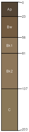
hillslopes / Shoulder hillslopes / Backslope interfluves
|
|
Crofton (45%)
Limy Upland
Udic Ustorthents
Well drained
Hydric: No
PAWS: 42 cm |
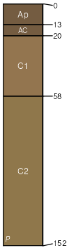
hillslopes / Shoulder hillslopes / Backslope interfluves / Summit
|
|
| SSA | Scale | Published | Export |
| ne003 | 1:20,000 | 1975 | 2025-09-03 |