Knobcreek-Crider-Gilwood silt loams, 6 to 18 percent slopes, eroded
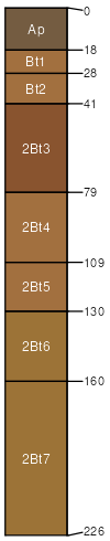
Knobcreek
(45%)
Deep Well Drained Limestone Uplands
Typic Paleudalfs
Well drained
Hydric: No
PAWS: 26 cm
hills / Backslope
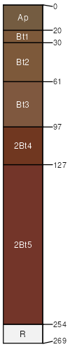
Crider
(35%)
Deep Well Drained Limestone Uplands
Typic Paleudalfs
Well drained
Hydric: No
PAWS: 29 cm
hills / Shoulder
hills / Backslope
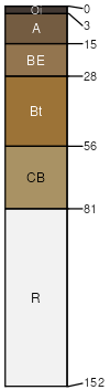
Gilwood
(20%)
Moderately Deep Siltstone-Shale Uplands
Typic Hapludults
Well drained
Hydric: No
PAWS: 13 cm
hills / Shoulder
hills / Backslope
SSA
Scale
Published
Export
in071
1:16,000
1985
2025-09-03