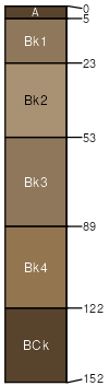
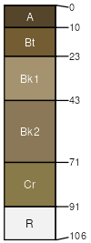
Bronec, bouldery-Geohrock, extremely bouldery-Kalsted, stony complex, 8 to 35 percent slopes

Bronec (30%)
Limy Droughty (LyDr) LRU 01 Subset A
Aridic Calciustepts
Well drained
Hydric: No
PAWS: 10 cm
hills
Geohrock (25%)
Droughty Steep (DrStp) LRU 01 Subset A
Aridic Haplustalfs
Well drained
Hydric: No
PAWS: 10 cm
hills
escarpments
Kalsted (15%)
Limy (Ly) LRU 01 Subset A
Aridic Calciustepts
Well drained
Hydric: No
PAWS: 18 cm
hills
Blackleaf (12%)
Shallow Droughty (SwDr) LRU 01 Subset A
Lithic Haplustalfs
Well drained
Hydric: No
PAWS: 4 cm
hills
Rock outcrop (5%)


Hydric: Unranked
PAWS: NA
Rubble land (5%)


Hydric: Unranked
PAWS: NA
Twinadams (4%)
Droughty Steep (DrStp) LRU 01 Subset A
Calcidic Haplustalfs
Well drained
Hydric: No
PAWS: 6 cm
hills
Dyce (4%)
Thin Claypan (TCp) LRU 01 Subset A
Aridic Paleustalfs
Well drained
Hydric: No
PAWS: 11 cm
hills
SSAScalePublishedExport
mt6121:24,00020112023-08-24