Till at 40 to 60 inches (%)
Hydric:
PAWS: NA |

|
|
Darker colored surface layer (%)
Hydric:
PAWS: NA |
|
|
|
Somewhat poorly drained soils (%)
Hydric:
PAWS: NA |
|
|
|
Houcktown soils with more clay in the surface layer (%)
Hydric:
PAWS: NA |
|
|
|
Areas underlain with lacustrine silts (%)
Hydric:
PAWS: NA |
|
|
|
Glynwood soils with less clay in the substratum (%)
Hydric:
PAWS: NA |
|
|
|
Thicker subsoil (%)
Hydric:
PAWS: NA |
|
|
|
Slopes of 12 to 25 percent (%)
Hydric:
PAWS: NA |
|
|
|
Slopes of 2 to 6 percent (%)
Hydric:
PAWS: NA |
|
|
|
Seasonal high water table at 2 to 3.5 feet (%)
Hydric:
PAWS: NA |
|
|
|
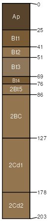
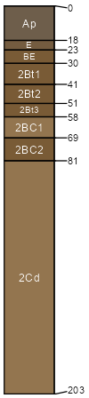
Houcktown (65%)
Lacustrine Forest
Till Ridge
Aquic Hapludalfs
Moderately well drained
Hydric: No
PAWS: 18 cm |
ground moraines / Shoulder ground moraines / Backslope
|
|
Glynwood (25%)
Till Ridge
Aquic Hapludalfs
Moderately well drained
Hydric: No
PAWS: 17 cm |
ground moraines / Backslope ground moraines / Shoulder
|
|
Very poorly drained soils (5%)
Hydric: Yes
PAWS: NA |
ground moraines drainageways
|
|
Severely eroded areas (5%)
Hydric: No
PAWS: NA |
ground moraines / Shoulder
|
|