Till at 40 to 60 inches (%)
Hydric:
PAWS: NA |

|
|
Surface layer less than 10 inches thick (%)
Hydric:
PAWS: NA |
|
|
|
Moderately well drained soils (%)
Hydric:
PAWS: NA |
|
|
|
Sandy loam surface layer (%)
Hydric:
PAWS: NA |
|
|
|
Silt loam surface layer (%)
Hydric:
PAWS: NA |
|
|
|
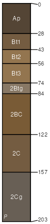
Aurand (85%)
Lake Plain Flats
Aquic Argiudolls
Somewhat poorly drained
Hydric: No
PAWS: 18 cm |
|
|
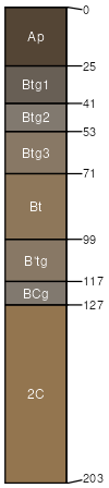
Alvada (8%)
Hydric: Yes
PAWS: NA |
|
|
Loamy very poorly drained soils with till at 20 to 40 inches (5%)
Hydric: Yes
PAWS: NA |
|
|
|
Hoytville soils at the margins of map units (1%)
Hydric: Yes
PAWS: NA |
|
|
|
Shawtown soils in more sloping areas (1%)
Hydric:
PAWS: NA |
|
|
|